Colonial Settlement Is a Tool for Social and Economic Engineering to Complete the Zionist Project
Introduction
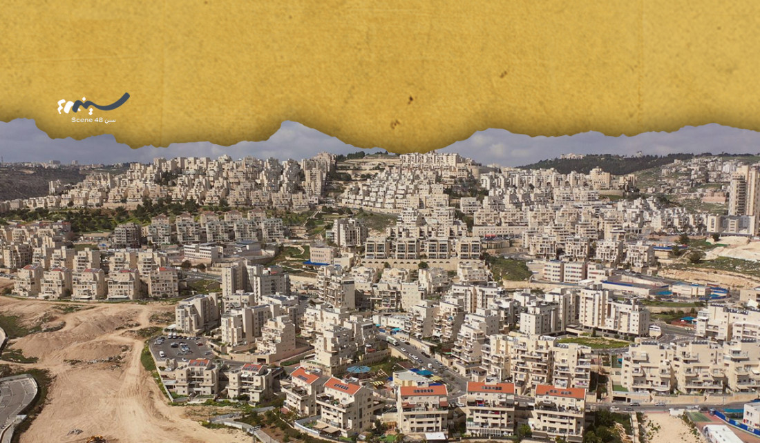
After the occupation of the West Bank, Gaza Strip, and Jerusalem in 1976, Israel began imposing new demographic and geographic realities. According to a report by the Israeli Ministry of Interior, about 340,000 settlers live in East Jerusalem, including Israeli settlements in the area sometimes called Greater Jerusalem (jpost.com). A report based on data from the Peace Now group indicates that the number of settlers in the West Bank will exceed 529,000 by 2025, with the pace of expansion and legislation for new settlements continuing.
The danger of settlement is not limited to the population increase of the settlers, but lies in reshaping the Palestinian geographical structure. The settlements have been positioned to prevent geographic continuity between Palestinian cities and villages by placing them in strategic locations such as the outskirts of Jerusalem (the Ma‘ale Adumim bloc), the central West Bank (Ariel), and the southern West Bank (Gush Etzion). This leads to the division of the West Bank into isolated islands that are difficult to connect and easy to control. (Falah, 2003)
The bypass roads established by the occupation to serve settlers, which consume Palestinian land, as well as the construction of the separation wall, which primarily aims to fragment the West Bank, isolate Jerusalem, and control more than 25 underground wells that have become behind the wall and inaccessible to Palestinians, are not related to any security need. These policies have created separate "population cantons" in the Palestinian territories, hindering planning for economic and social development, fragmenting the unity of the Palestinian community, and limiting its ability to endure and resist. (Khalidi, 2006)
Demographic change and land confiscation are among the most prominent tools used by the Zionist project to achieve its goals in Palestine. Since the early days of the Zionist movement, settlement has significantly increased in agricultural, industrial, and residential forms; vast areas of Palestinian land have been confiscated under the pretexts of "state land," "public benefit," or military purposes, and are often later converted into settlements or closed military zones. (B’Tselem, 2023) Moreover, Israel controls most of the water sources in the West Bank and allocates the lion's share of water resources to the settlements, while imposing strict restrictions on Palestinians' use of their natural resources, leading to near-total economic dependence on Israel. (Al-Haq, 2022) At the beginning of 2026, the occupation authorities issued a law allowing settlers to purchase land personally and announced the confiscation of land in Area C and the funds of so-called expatriate properties.
These demographic and economic policies aim to re-engineer Palestinian society, making it less capable of resilience and independence, and more prone to migration or displacement, thereby serving the long-term Zionist goal of controlling land, resources, and people. The most dangerous aspects are the invisible dimensions of colonial settlement in the West Bank, which constitute a structural distortion of land and population distribution. Here are some features of these distortions:
The Invisible Economic Dimensions
A. Water and Agriculture
Israel controls 80% of groundwater and 75% of the Jordan River, which prevents Palestinians from utilizing water for economic development, especially in agriculture. Palestinian losses in this regard are estimated at approximately $45 billion, which could have been returns from agricultural water over nearly 59 years. Israel also controls agricultural areas, and the Palestinian economy, including labor and products, has lost approximately $33 billion over the years of occupation since 1967.
B. Types of Settlements
Because Israel is no longer able to attract residents to the settlements as it used to and at the pace it desires, it has started changing the pattern of settlements and shifting toward agricultural and industrial settlements. (Yakir and Bruchin) Agricultural settlements in the Jordan Valley were expanded, where a single settler can exploit and control thousands of dunams, as happened in the Dolev settlement northwest of Ramallah.
Statistics indicate that Israel faces a dilemma in how to populate the settlements, as immigration to Israel decreased from 500,000 between 1991–1995 to around 100,000 between 2011–2015. (Zaytouna Center, 2015) This has led Zionist thought to take new directions, renewing the idea that a good Zionist is measured by the area he can control.
C. Invisible Dimensions in Planning
To clarify how Israeli settlements besiege Palestinian geographic areas and cause them to lose their ability to expand or even change the shape and architecture of Palestinian villages, consider the cases of the city of Ramallah and the village of Ein Yabrud. Both have limited possibilities for expansion because they are surrounded by settlements. The bypass road serving settlers has created a barrier preventing expansion of the most active villages in the area, forcing residents to build multi-story structures, which has deprived those villages of their traditional appearance.
E. Change in Cognitive Awareness
Israel has consistently assigned Hebrew names to geographic locations in an attempt to distort cognitive awareness. For example, it has changed the names of springs and given settlements names derived from their original Arabic names, such as Ramounim and Kedumim from Ramoun and Kfar Qadum. Additionally, anyone traveling from Qalandia to Nablus will notice 73 signposts for settlement names, while only five signs refer to Palestinian communities. This makes the settlements seem like part of the Palestinian landscape. New names are being used in line with Israeli desires: the Nabi Saleh intersection has become the Halamish junction, and Huwara Street has become the Itamar intersection. This means that settlement geography is encroaching on our geographical and cultural references.
F. The Wall: Completing Control over the Western Aquifer Basin
From a hydrological perspective, the wall is not surprising; rather, it is an extreme physical application of various Israeli efforts and theories over past decades to control the vital western water aquifer.
If we trace the engineering path of the wall, we find that it actually follows the boundaries of the groundwater. The least negative impact of the wall is that it prevents the flow from reaching Palestinians opposite the basin's direction, thereby ensuring that Israel has full control over the quantity and quality of the water.
Israel aims to ensure complete control over the basin by building the wall, creating facts to be negotiated in what are referred to as final status negotiations. The basin is located beneath the most fertile lands in the West Bank, and therefore use of water in these areas is closely linked to agriculture.
The impossibility of accessing land due to the wall will turn these Palestinian fertile lands into dry, unusable land within a few seasons, since the agricultural sector will initially diminish before disappearing completely.
This deliberate creation of facts will render the land effectively unusable, and when Palestinians demand access to water in any negotiations between the two parties, Israel will respond that the request is unfounded. It is a fixed and inherent aspect of Israeli procedures and laws that Israel will use such facts to convince the international community that Palestinian demands are baseless, and that the need for water for agriculture in the northern West Bank does not reflect current reality.
The wall goes hand in hand with Israel's ongoing attempts to control Palestinian lands and turn Palestinians into cheap labor. Agricultural communities and their entire way of life are at risk, especially since residents in the area around the first phase of the wall, who depend on their lands, will and have already begun to move deeper into the West Bank in search of work to compensate for income lost due to the loss of their agricultural lands. This, on one hand, confirms that the number of Palestinians in the area will decrease, paving the way for more Israeli control. At the same time, there is no infrastructure or viable alternative for the jobs Palestinians have lost, and thus their only options will be hunger or working for the Israelis. (Tamimi, 2013)
"Security" is a false pretext used by the Israelis, and the claims of Israeli spokespeople to the contrary make it necessary to reiterate that the construction of the wall is not a security measure. If the construction of the wall were for security purposes, then how could Israel claim security and separation while annexing and including more than 15 village clusters in the first phase alone west of the wall? Why was the largest and first phase of the wall built in the north and not in the south or center of the West Bank? The answer is clear: the path of the wall aligns with a hydrological reality rather than the geographic reality of the area, and this provides further evidence that the wall, in its initial and most important phase, is part of Israeli policy of land and water appropriation.
Summary
The policies of re-engineering Palestinian society have never been merely reactive; rather, they are a systematic, integrated, and cumulative socio-economic and demographic policy since the establishment of the Zionist movement. (Khalidi, 2006; Musalha, 2012) This control seeks all historic Palestine with the minimum number of Palestinian residents.
The tools of this societal engineering vary across Palestinian geographic spaces: in the West Bank, policies focus on deepening settlement, fragmenting geography through the separation wall and bypass roads, and imposing administrative divisions (A, B, C) that hinder any urban or social unity. Inside Israel, the tools are discriminatory laws, land confiscation, and "Judaization of the place" policies that work to dissolve Palestinian national identity and enhance Jewish control over space and urban development. (Human Rights Watch, 2021) In the Gaza Strip, the suffocating blockade and repeated military operations emerge as mechanisms to weaken infrastructure, economy, and social fabric, pushing the population toward migration. (B’Tselem, 2023; Al-Haq, 2022)
Despite the multiplicity and integration of these policies, they share a single strategic goal: ensuring permanent control over land and resources, and minimizing the Palestinian presence politically, demographically, and culturally. However, the study reveals the Palestinian community's ability to innovate multiple resistance mechanisms, ranging from popular resistance and alternative planning to preserving national and cultural identity, and using legal and media tools to document violations and expose settlement policies. Israeli societal engineering was not met with surrender; rather, it became an open field of conflict between policies of dismantling and exclusion and the efforts of Palestinians to rebuild the nation and preserve existence and rights. This interaction keeps the Palestinian cause alive in regional and international consciousness, making the future of Palestinian society subject to transformations, resistances, and challenges.
References:
Al-Haq. (2022). Annual report: Israeli violations in the occupied Palestinian territory. Ramallah: Al-Haq Organization.
B’Tselem. (2000). Thirsty for a solution (p. 20). Jerusalem.
B’Tselem. (2023). Gaza: Economy, health, and siege. Retrieved from https://www.btselem.org/gaza_strip
B’Tselem. (2023). Statistics on demolitions and planning. Retrieved from https://www.btselem.org/statistics
B’Tselem. (2023). Statistics on discrimination and planning.
B’Tselem. (2023). Statistics on settlements and occupation. Retrieved from https://www.btselem.org/statistics
Duggar, J. (2002). Special Rapporteur of the Commission on Human Rights, report no. A/57/366.
Human Rights Watch. (2021). A threshold crossed: Israeli authorities and the crimes of apartheid and persecution. Retrieved from https://www.hrw.org
Isaac, J. (2000). Environmental degradation and the Israeli Palestinian conflict. Applied Research Center, Bethlehem.
Khalidi, R. (2006). The iron cage: The story of the Palestinian struggle for statehood. Boston: Beacon Press.
Khalidi, W. (Ed.). (1997). All that remains: The Palestinian villages occupied and depopulated by Israel in 1948. Washington, D.C.: Institute for Palestine Studies.
LAW. (2000). An overview of consequences of Israeli occupation on the environment in the West Bank and Gaza Strip [Unpublished manuscript].
Ministry of Environmental Affairs. (2001). Palestinian environmental strategy.
Musalha, N. (2012). The politics of denial: Israel and the Palestinian refugee problem. London: Pluto Press.
Palestine Monitor. (n.d.). Fact sheet. Retrieved from www.palestinemonitor.org
PHG (Palestinian Hydrology Group). (n.d.). Database. Retrieved from www.phg.org
Tamimi, A. (2007). Theory into practice: Final implementation. The wall's path is based on ultimate control over Palestinian water resources. Palestine Times, issue 31/5/2007.
United Nations. (2015). Report on the situation of human rights in the Palestinian territories occupied by Israel since 1967.

Dr. Abdel Rahman Al Tamimi
A part-time lecturer at the Institute of Sustainable Development at Al-Quds University with over 25 years of experience in water resource management, governance, policy, institutional reform, and integrated rural development. He has led and contributed to international research projects, published widely on water, institutional building, and transboundary conflict, and served as a consultant to major international and Palestinian institutions. He is the author of Water Privatization and Regional Political Agenda, co-author of Mediterranean Challenges 2030, and a member of national reform and social agenda committees.
Related Articles